Drone-based turf analytics for centimetre-level certainty.
PhytoMaps started as a drone-based turf analytics company, and it's still at the heart of what we do. When the satellite layer flags something, or when you want the most detailed picture available, a multispectral drone goes up. We stitch the imagery, run the analytics, and deliver the reports on the portal.
From those analytics we also generate prescription maps you can load straight into a GPS-guided sprayer (John Deere, Toro and similar) to spot-spray only the zones that need it.
If your team owns a drone and can fly it, send us the raw imagery and we'll do the rest. We also handle the deeper seasonal scans we run in spring, summer and autumn.
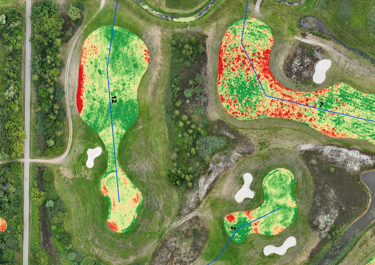 NDVI overlay~2 cm / px
- High-resolution multispectral imagery
- Written interpretation by specialists
- Concrete on-the-ground recommendations
When to bring in drone analytics.
Satellite is enough for most decisions. Drone analytics are the right call when you need certainty, resolution, or a defensible record.
Seasonal full-property scan
A scheduled deep-dive across the entire course in spring, summer and autumn. The most complete picture of how the season is going.
A flagged zone needs a closer look
Satellite says something is wrong in a specific zone. The drone tells you exactly what's happening at centimetre resolution.
Treatment verification
Fly the area before treatment and again afterwards. See exactly what changed, for your own team and for the agronomist.
Disputes and insurance
A defensible, dated, high-resolution record of the state of the course on a specific day.
What you get back.
Every drone scan delivers a complete package, not just imagery.
- 01
High-resolution multispectral report
Centimetre-level imagery and per-zone statistics, in a format that's easy to share with your team and your stakeholders.
- 02
Written interpretation
Not just images. We tell you, in plain language, what we see and what stands out.
- 03
Recommendations
Concrete next steps you can act on, or hand to your agronomist.
- 04
Prescription maps for spot spraying
Health maps turn into rate-controlled prescription files (shapefile or GeoTIFF) you can load straight into a GPS-guided sprayer (John Deere, Toro and similar) so the boom only opens over the zones that need it. Most clubs cut chemical use by half or more.
Ready for a closer look?
Tell us about your course and where you'd like the analytics to focus. We'll come back with options, including dates if we're flying or upload instructions if your team flies your own drone.
Request a drone scan